
Kazakhstan Can Now Predict Floods — So Why Can’t It Prevent Them?
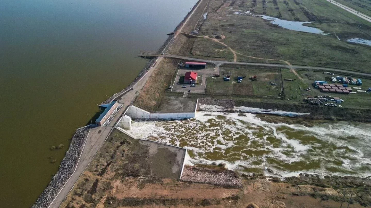
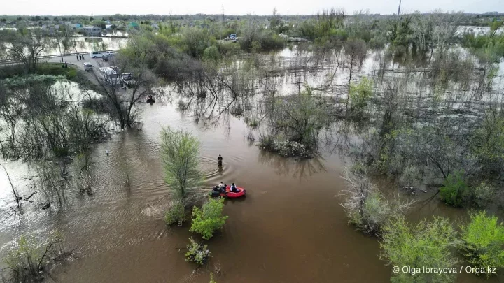 Photo: Olga Ibrayeva
After the floods of 2024, Kazakhstan launched a high-tech forecasting platform called Tasqyn, developed by the national aerospace company Kazakhstan Gharysh Sapary.
Its goal: to detect flood risks early and guide timely decision-making. But as recent events have shown, even the most accurate predictions are of little help if there’s no infrastructure or resources to withstand nature’s force.
What exactly is Tasqyn?
Orda.kz has investigated.
How The Tasqyn System Operates
Tasqyn is Kazakhstan’s first unified flood modeling platform. It brings together data from multiple government agencies — including Kazhydromet, the Ministry of Ecology and Natural Resources, the Ministry of Water Resources and Irrigation, and the Ministry of Emergency Situations — to create comprehensive forecasts.
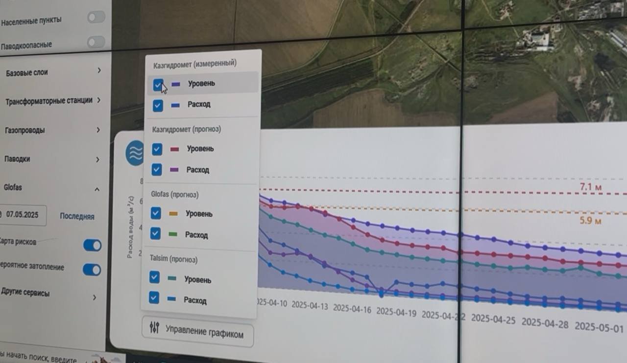
For the first time, we have an integrated tool that can predict, up to 30 days in advance, which river basins are likely to face a critical rise in water levels, says Berik Rakhimzhanov, Director of the Spatial Data Analysis Department at Kazakhstan Gharysh Sapary.
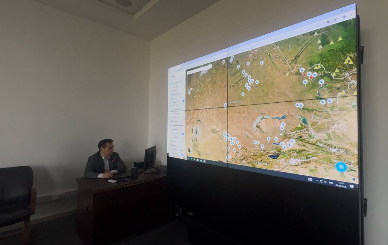
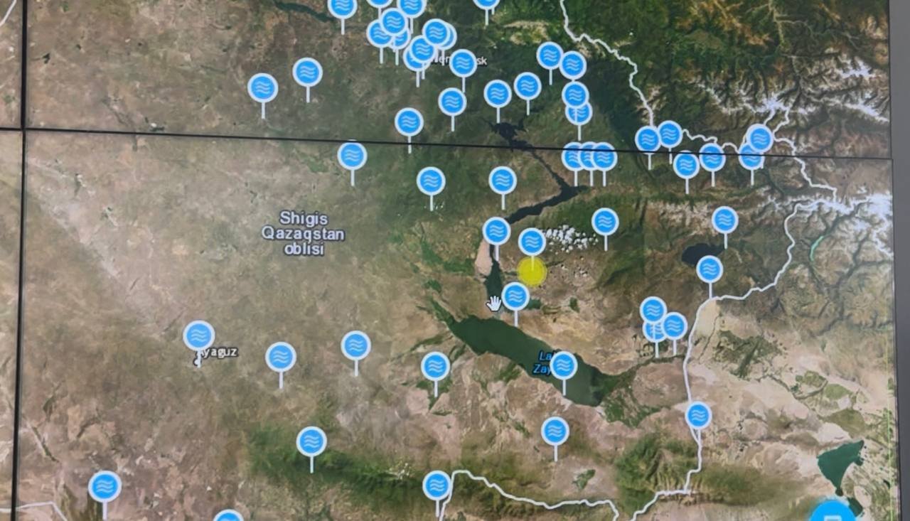
The Tasqyn system gathers data from hydroposts (in 2024, there were 377 permanent ones, along with 44 seasonal posts), as well as digital elevation models and satellite imagery.
But it’s not just about collecting data — Tasqyn serves as a powerful spatial analytics tool. It calculates potential water flow, predicts which settlements might be affected, and even estimates when floods could occur.
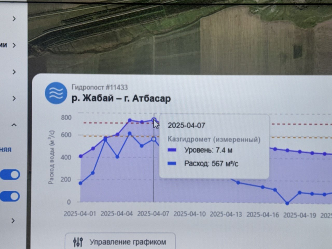
We had a preliminary forecast for March 21, followed by the main forecast on March 28. Then, we received short-term updates on April 4, 11, and 18. These forecasts provide data on the hydropost number, the current water levels, how many meters above the zero point the water is, and when the peak is expected. With this information, we can model the water's path using the digital elevation model and identify which settlements are at risk downstream,explains Rakhimzhanov.
Kazakhstan has never seen this level of data integration before.
This is a decision support system. It provides an early warning so that the Ministry of Emergency Situations can prepare, and local authorities can mobilize people and resources to carry out flood control efforts, explains Rakhimzhanov.
Tasqyn’s developers aren’t just maintaining the system but also training officials across the country to use it effectively.
Our specialists traveled to the regions, conducted both in-person and online training. We create user accounts, provide logins, and consult with users to help them get the most out of the system,he adds.
Why Predict if You Can’t Prevent?
The floods of 2024 were the driving force behind the creation of this advanced forecasting platform.
Commissioned by presidential order, Tasqyn was meant to help prevent a repeat of last year’s disaster.
Prediction alone isn't enough, as the spring of 2025 has already shown, with several villages inundated in the Aqmola and North Kazakhstan regions.
According to Rakhimzhanov, there are limits to what technology can do when faced with overwhelming natural forces:
When a billion cubic meters of water is on its way over the course of 20 to 30 days, it’s simply impossible to stop it physically.

According to Tasqyn data, a flood wave in the North Kazakhstan region was detected 20 days before water levels reached a critical point.
Local authorities had access to that information.
Still, whether due to limited resources or the difficult cost-benefit decisions involved in flood prevention, not all protective measures were taken. As Rakhimzhanov explains, resource management principles come into play — it’s not just about saving settlements, but also using public funds wisely.
You can’t just spend money blindly unless you know those measures will actually be necessary. You have to be sure the facilities will be used,he says.
This kind of caution is one reason why local emergency responses can lag even when forecasts are available, giving water time to reach homes.
According to Rakhimzhanov, early warnings still serve a vital purpose: they give communities time to evacuate and allow authorities to prepare for emergency response.
He also notes that Tasqyn is just one part of the decision-making process. When regional response teams meet, they evaluate not only model forecasts but also data from local officials, emergency services, drone footage, aerial surveys, and real-time updates from satellite-connected monitoring posts.
This kind of integrated response has worked in some areas, like the Aqtobe region. Vulnerable zones were identified using Tasqyn, and thanks to that early insight, protective measures were put in place.
Based on the modeling, we pinpointed weak spots — areas where a dam or protective structure was needed, where water needed to pass through. Roads were paved, cleared, or even dismantled to let the water flow, Rakhimzhanov recalls.
Why It Floods Every Year — And Why It’s Not Always a ‘Flood’
Not all flooding is caused by overflowing rivers.
Here we need to distinguish: there are flooding from rivers, melting snow, and rising groundwater. At first glance, it all just looks like a flooded house. But specialists can tell what kind of water caused it,explains Rakhimzhanov.
For instance, meltwater flowing from the steppe can cause problems if river channels are still blocked by ice. In that case, water travels across the surface and floods villages.
You can’t stop that kind of water. You can’t build concrete walls around every village.
If the issue is groundwater, solutions like drainage systems may help. But even these aren't always effective if the water source is entirely different. Sometimes, it’s simply rainwater that accumulates in low-lying terrain with nowhere to go.
Rakhimzhanov insists that separate analytical work must be conducted before spending money on protecting a particular settlement.
Each region and each case needs its own analysis. Only then can we take measures and build what is really needed.
Why Was Spring 2025 Different?
The flood situation in 2025 is markedly different from what Kazakhstan experienced the year before, even though the amount of snow was roughly the same. According to Rakhimzhanov, the key difference was how the snow melted. In 2024, everything melted within a week:
There was no way to stop it. The main reason is the sharp temperature jump: in a week, it rose from -8 degrees to +10 degrees. Everything melted at once, and no measures could hold back the flow. If you had flown over the steppe in a helicopter with the Ministry of Emergency Situations, you’d have seen the steppe flooded to the horizon, like a real ocean. It was nearly impossible to fight against that.
Although the international GloFAS system had issued warnings in 2024, Kazakhstan lacked a local interface capable of interpreting that data in time. Had Tasqyn existed then, Rakhimzhanov believes the damage might have been reduced, though not completely prevented.
In contrast, 2025 brought a more gradual melt, unfolding in three distinct waves.
First, the local basins filled up, then came the main flow along the Yesil River, followed by the Jabay and Koluton tributaries. Satellite images and model forecasts clearly showed this pattern. It was three waves — not one massive surge.
However, the danger hasn’t passed for everyone. In the East Kazakhstan region, the threat of flooding persists well beyond the typical spring season.
The East Kazakhstan region hasn’t hit its peak yet. Some rivers there are fed by glaciers so that the flood-prone period can last until August.says Rakhimzhanov.
Tasqyn continues to monitor and reflect these regional risks.
The Information Exists — But Not for Everyone
As of now, access to the Tasqyn system is restricted to government agencies. The public can’t view the platform, and the developers say this is intentional.
There’s been criticism about the system being closed to the public. But even we, the developers, can’t always interpret the hydrographs correctly. That’s the hydrologists job.
He warns about the risk of misinformation if complex data is made freely available, especially when hydrographs fall into the hands of untrained journalists and bloggers.
Each river has its own character, like a person. To understand its behavior, you must be an expert. If you open access to the graphs to everyone, it can lead to distorted conclusions. This shouldn’t turn into some kind of uncontrollable process — a source of chaos, where untrained bloggers look at a few charts and start causing panic. That kind of approach won’t lead to steady, thoughtful progress. Data interpretation must come from specialists working in the flood-affected areas.
That said, the Tasqyn team is working to broaden access carefully. They’re partnering with universities and research institutions, aiming to provide access to scientists, hydrology-focused journalists, and veteran specialists.
The goal is to build a knowledgeable community that can interpret the data responsibly and explain it clearly to the public.
The Cost?
There’s no official figure for the platform’s development or operational costs. It’s fully funded by the national company Kazakhstan Gharysh Sapary.
All the software, the digital terrain model, satellite imagery — is developed in-house. We didn’t buy any separate equipment,Rakhimzhanov clarifies.
The company’s press service adds that, because Kazakhstan Gharysh Sapary also conducts commercial activity, the financial details of the platform remain internal.

The company also noted that 39 specialists worked on developing the Tasqyn system — 37 of them full-time employees of Kazakhstan Gharysh Sapary.
Two external experts — a hydrologist and a business analyst — were also brought in. They provided the specialized knowledge needed to ensure a high level of subject expertise, the company's press service stated.
Currently, the system is fully maintained by in-house staff, and no additional funding is drawn from the state budget.
What Does Kazakhstan Still Lack?
Beyond cautious budgeting, one of the biggest challenges remains the lack of data. Kazakhstan has too few automated hydroposts, outdated meteorological models, and gaps in key measurements like soil freezing and snow depth.
As far as I know, the number of hydroposts we have now simply isn’t enough for our territory. We need more of them — and they need to be automated, says Rakhimzhanov.
He also points out that the meteorological side of flood forecasting needs serious upgrading.
We should be measuring things like the depth of soil freezing and the height of snow cover during winter. The more detailed and automated the input data is, the more accurate the forecasts will be.
In addition, up-to-date aerial photography of residential areas is needed to revise water protection zones and prevent construction in high-risk areas. Rakhimzhanov also stressed the importance of improving water infrastructure management and conducting bathymetric surveys.
Bathymetry is the study of reservoir bottoms using sonar. These surveys have already been planned, and our colleagues are currently working on them,Rakhimzhanov says.
But even with better tools and technology, Kazakhstan still lacks the long-term experience in flood forecasting that some other countries have.
If you look at foreign experience, take the colleagues from Holland, for example. They’ve been recording river levels — when and by how much they rise — since the 18th century. Because this country lives with water, water management is part of its national identity. As far as I know, we’ve only had continuous meteorological observation here since the 1920s. Rakhimzhanov says.
The Tasqyn system is a major step forward, helping shift Kazakhstan’s approach to flood forecasting from guesswork to data-driven modeling. Still, it’s not a complete solution.
Tasqyn can predict when and where floodwaters will hit. But it can’t build dams, allocate emergency funding, or coordinate evacuations.
As Rakhimzhanov himself puts it:
The information system is not a scientific breakthrough. We have created an interface that combines data from different government agencies to support decision-making.
And for now, making those decisions — especially the political and financial ones — seems to be the system’s weakest link.
Original Author: Zhadra Zhulmukhametova
Latest news
- Two Injured Russian Climbers Rescued From Almaty Mountains
- Kazakhstan Denies Reports of Full CPC Shutdown
- South Korea to Help Kazakhstan Forecast Demographic Change
- Almaty Waste Company Stake to Return to State After Undervalued Sale
- Inspection of Former Almaty Akim’s Family Project Declared Illegal
- Kazakhstan Could Refine Russian Oil as Russia Faces Fuel Shortages
- Who Is Behind the Company Searching for Copper Near Atbasar?
- Almaty Airport to Take Out $670 Million Loan
- Kazakhstani Woman Dies in Belgrade, Father Suspects Her Friends Were Involved
- Who Will Keep Health Coverage Under Kazakhstan’s New Rules?
- Fake Journalists Tricked Karaganda Official Into Taking Out Loan
- Pavel Durov Declared a “Terrorist” in Russia
- Lawsuit Pushes Oskemen Authorities to Adopt New Alert Rules After Kazzinc Explosion
- Emergency at Pavlodar Power Plant: Two Workers Seek Medical Help
- What Back-to-School Aid Has Been Promised to Vulnerable Families?
- Employment Falls at Kazakhstan’s Small and Medium Businesses
- How Much Will It Cost to Ride Astana’s LRT From August 1?
- KASE and AIX Record Sharp Rise in Trading Activity
- Ten-Year Record: More Kazakhstanis Are Losing Their Driver’s Licenses
- What Can Tourists Expect? Kazakhstan Approves New Rules for Visitor Centers